Home
WebLakes.com
WebMET
Terrain Data
US
7.5-min DEM
1-deg DEM
SRTM1
Global
SRTM3
SRTM30
GTOPO30
LULC Data
US
Shapefile (Lat/Long)
Shapefile (UTM)
Standard (UTM)
NLCD92
Global
GLCC
Base Maps
US
DLG Data
Terra Server
Libre Map Project
Global
LandSat (MrSID)
USGS Seamless
Shoreline Data
Global
GSHHS
Contact
About


terrain data

Terrain Data

SRTM3 - Shuttle Radar Topography Mission
Global Coverage (~90m) Version 2

Resolution: ~90 m, 3 arc-sec
Coverage: Global
Projection: Geographic
Datum: WGS84
Vertical Units: Meter

Islands Africa Australia North America South America Eurasia Islands

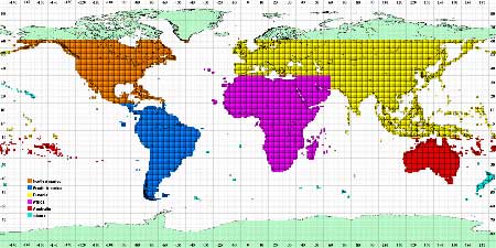
Click on desired region to download terrain data. The links are
connected directly to the NASA site (courtesy of NASA/NGA/USGS).


This data was collected during the Shuttle Radar Topography Mission (SRTM) and contains global coverage from 56 degrees south latitude to 60 degrees north latitude in 1 by 1 degree blocks with an approximate resolution of 90 by 90 meters. For further detail, please read the Info, Documentation or the Quick Start.


Air Dispersion
Modeling & Risk
Assessment


#1 Meteorological Resource Center


courses
courses
CALPUFF View
Advanced Air Dispersion Model


Home | Terrain Data | LULC Data | Base Maps | Shoreline Data | Contact | About

Copyright © 2002-2009 Lakes Enviornmental Software
www.WebLakes.com | www.webGIS.com | www.WebMET.com